
Highways & Byways is just starting to come together as a cohesive project! Despite working at my day job every day this week, I’ve managed to dedicate a full 10 hours this week to game development and game development alone. I think this is important. I’m still dealing with sales, marketing, and fulfillment from War Co., you know! It would be very easy to slip into day-to-day routines that do not advance Highways & Byways.
Need help on your board game?
Looking for more resources to help you on your board game design journey?
This week I’ve reached a major mile-marker. The board is filled with byways and breakpoints. Highways & Byways is a game based in geography, and specifically, the location of beautiful – and often obscure – roads in the United States. I’ve selected 72 byways that span the contiguous 48 states. Every state has at least one byway. Breakpoints will be areas where pieces will eventually be placed and moved along the board. Breakpoints are currently about 100 miles apart.
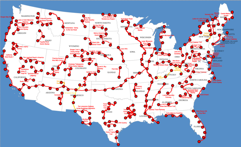
The image above is what my game looks like right now. As you can tell, it’s a very noisy board with a lot of information. A major challenge of this game will be coming up with an elegant way to deliver this immense amount of information to players. You don’t want to overwhelm your players with data! I’m not concerned with that right now because that is something I can refine later. The creative process, much like bodybuilding, involves bulking first and cutting back later.
You may wonder how I’ve chosen all these byways. My browser history is rife with websites like “Federal Highway Administration Scenic Byways and All-American Roads”, “Wyoming Department of Transportation”, and “Scenic Nebraska Drives”, and “10 Absolutely Beautiful Roads You Have to Drive in Texas.” Every single road is chosen for either its scenery or its historical significance. Indeed, I’ve been checking them out on Google Images and Google Earth to make sure they live up to the hype. I want every byway on this board to be a real and amazing place that you can really go to. I hope to include the real directions on driving each road in the final game, but let’s see what happens.
Of course, I can’t just indiscriminately place scenic roads on the map. There’s a few requirements. I don’t want roads to overlap, with a couple of exceptions. I don’t want roads to intersect often, either. I want a road in each state, but I don’t want roads to be cluttered and too close together. I have to keep them spread across the country. That means some super-obvious roads (like the Grand Canyon drive) have to give way to obscure ones like the Dine’tah Road. There’s also a diverse array of cultures in the United States that I’d like to represent while I’m making this game…but gameplay is my first priority. Point is: creating a map for Highways & Byways requires a lot of trade-offs.
I have priorities set for the coming week. The next stop on this tour is simple: fill in highways between the breakpoints on byways. I need to connect all these roads so players can travel across the map. Then, once I have a cohesive, navigable map, I’ll be doing some early-stage self-testing to take measures on movement speed. This will affect how I set objectives and constraints in the game.


3 thoughts on “Dev Diary: 03/24/17”